

SIG · Ciencia · Datos
NISAR: The Instrument That Measured Sevilla's Movement
A blow still being measured
On August 10, 2026, at 7:34 in the morning, a magnitude 7.4 earthquake rooted 103 kilometers down under San José del Palmar, in Chocó, shook western Colombia; according to reports from Colombia's Geological Survey, the tremor was felt as far as Panama and Venezuela. In Sevilla it left 2,833 damaged homes and more than 11,000 displaced people, and the reconstruction, to this day, remains in progress. The emergency is over and the grief still belongs to the people, although the event has not finished being counted; besides the housing tallies there is another accounting possible, that of the ground itself, how far the earth under an entire municipality shifted on the morning of the quake.
An instrument that needs no light
Getting to know NISAR up close, as we did during the training from the NASA ARSET program, reorders what you thought you knew about Earth observation. The satellite launched on July 30, 2025 from Sriharikota, on the Indian coast, the result of joint work between NASA and ISRO, that country's space agency. Its full name is NASA-ISRO Synthetic Aperture Radar, the first Earth-observing satellite equipped with two radars operating simultaneously, one in L-band, 24 centimeters of wavelength, contributed by the American side, one in S-band, 12 centimeters, contributed by the Indian side, both feeding a single 12-meter reflector that unfolded in orbit like an umbrella and sweeps swaths some 240 kilometers wide. The design closes with a decision especially valuable for territories like ours, an open, free data policy putting the entire catalog at any user's disposal, without fees or paperwork.
The instrument's qualities are best appreciated against an ordinary eye. Radar operates independently of sunlight and of weather, works at night, cuts through cloud and rain, and instead of recording colors it records echoes, the time a microwave signal takes to travel down, reflect and return. Synthetic aperture exploits the satellite's own motion to simulate an antenna of enormous size, which yields the fine resolution; interferometry, for its part, is the stage where displacement measurement actually happens. It compares the phase of echoes between two passes over the same terrain and, since phase is a fraction of the wavelength, a movement of a few millimeters gets written as a shift in that fraction, one full cycle corresponding to roughly twelve centimeters of displacement. The design decision we highlighted most after training is the L-band, whose 24-centimeter wave penetrates the canopy and reflects off trunks and soil, keeping coherence between passes exactly where shorter-wave radars lose it, in the landscape we know well, coffee mountains soaked and covered in trees.
Processing the data
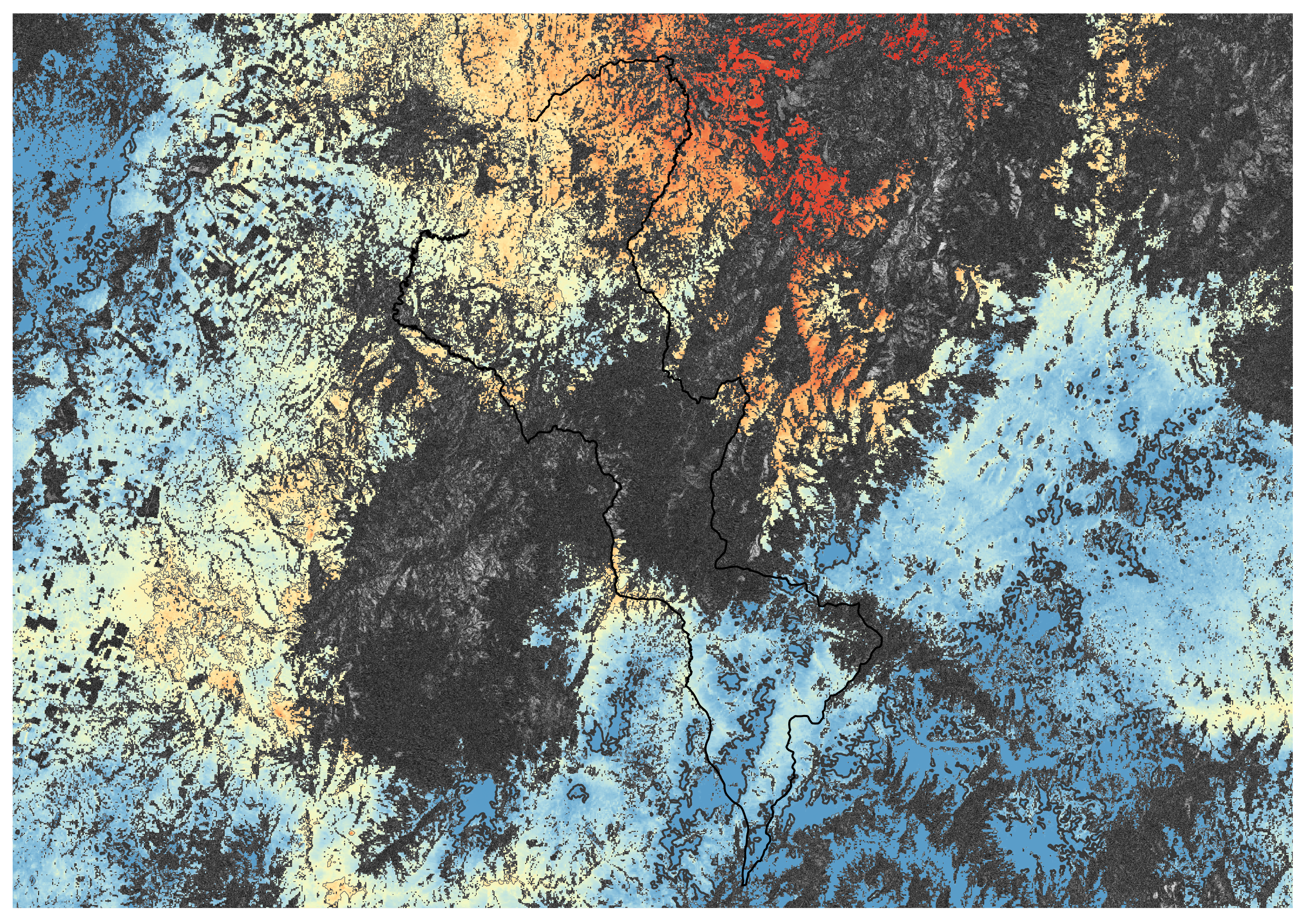
NISAR flies over practically the entire land surface every twelve days, so its calendar already contained the pair of images bracketing August 10, one pass before and one after; since July 2026 NASA publishes calibrated L-band data, and we downloaded the geocoded interferogram of the pair, which arrives pre-processed, carrying the unwrapped phase, the coherence, and even the ionospheric correction inside the same file. In QGIS, with free software, we subtracted that correction, converted phase to centimeters of motion, and masked the zones where the measurement is too noisy to sustain honest claims. The whole process ran on public data and free tools, a few hours at a desk in place of laboratory time and budget.
What the map says
The result is a map of the municipality where the ground shifted up to 58 centimeters toward the satellite's viewpoint on the slopes closest to the rupture, and about 22 in the opposite direction on the far side of the pattern, arranged in lobes of opposing sign around the rupture zone, an arrangement from which the event's geometry can be inferred. The technical reading deserves to be stated in full; these are centimeters of displacement along the radar's line of sight, one component of the real motion, with gaps where the terrain returned no sufficient signal. Even so the conclusion holds, the ground under an entire coffee municipality shifted half a meter in a single morning, that record rests in a public repository, and anyone can verify it with a computer and the same source a seismologist would use. More than a figure follows from the pattern; the lobes mark where the motion was most violent, the gradient orders the territory by intensity, and that distribution can be crossed with the damage cartography to ask, later on, whether geology, slope or construction quality explained who suffered most.
Readings going forward
The instrument's promise lies less in August's earthquake than in what came after, and in what comes next. Over a Sevilla in reconstruction, each pass makes it possible to track how the terrain keeps settling, how unstable slopes behave, how new fills and works subside; for the rest of the country, the same routine covers landslides, urban subsidence, volcanoes and glaciers, systematic coverage of the whole territory renewed every twelve days and available at no cost. That is Red LabOT's terrain, the blind spots of information, data scattered across technical bulletins and institutional archives; gathering them into readable maps, as regional partners of the NASA Lifelines program, is the work this exercise sums up. If the subject interests you, whether you work in risk management, territorial planning or simply want to understand what is happening beneath your own ground, use our contact form; there is much more to tell, and we want to tell it to whoever needs it. The orbit continues regardless of grief and reconstruction, every twelve days the satellite takes the measurement again, and reading it with discipline is what we learned and what we intend to teach.
Comentarios
Cargando comentarios…
Deja un comentario
Tu comentario se revisará antes de publicarse. Tu correo no se mostrará públicamente.